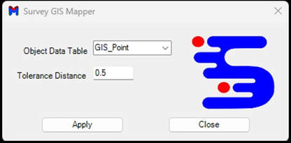
SURVEY GIS MAPPER Ai SOFTWARE
Expert GIS data management software for surveyors. Auto attach your AEC cogo survey points as GIS data attached to your breaklines, linework, blocks, and symbols. Manage your GIS data quicker. Utilize any GIS object data table. Auto-set your GIS data faster for your entire survey master drawing with one click of a button. This amazing super-fast GIS data automation tool works with Cogo Point Codes ATT-ATT22. Supports AutoCAD Civil 3D software and is included with the purchase of Survey Mapper software.
AutoSet GIS Data Tool for Survey Projects