Route Mapper AI
Route Mapper Ai is the world’s #1 CAD–GIS digital twin engine for linear infrastructure.
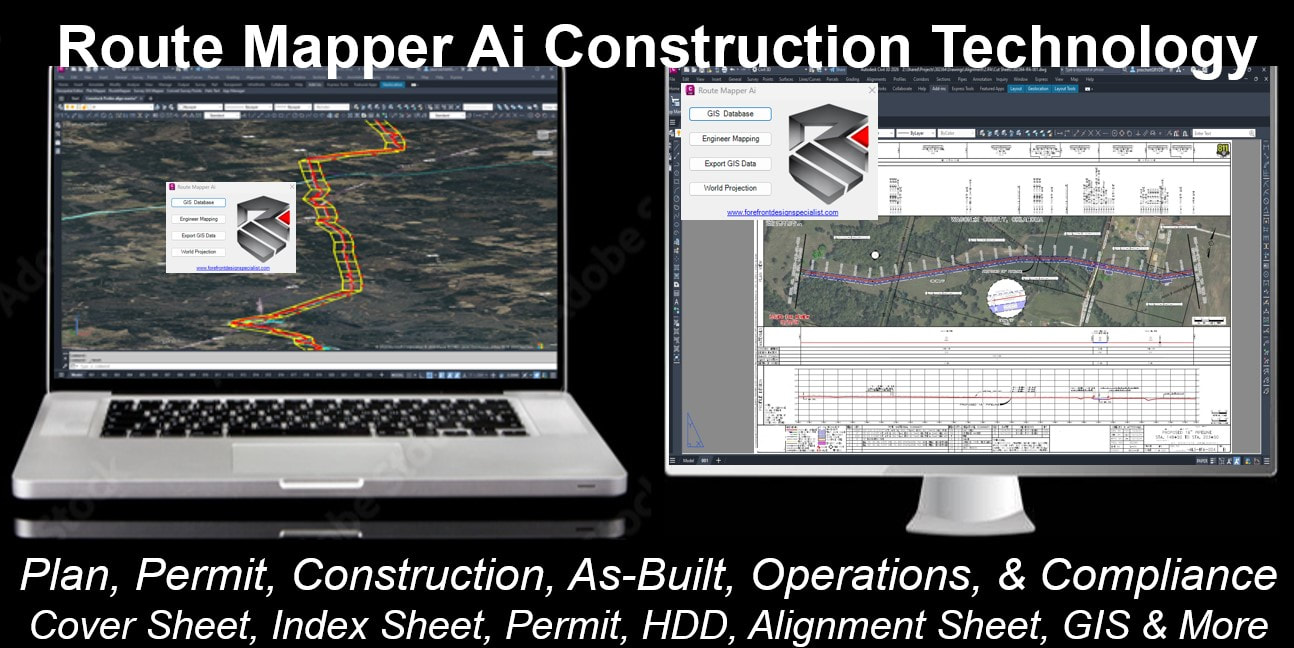
It auto-design-builds full engineering drawing packages, manages GIS and survey data, and delivers project-critical intelligence — smarter, faster, and more efficiently than any solution on the global market.
Route Mapper AI is a 2D–3D centerline-based digital twin engine. It anchors every project to a single, living model that evolves across the entire lifecycle — from design and construction to as-built documentation and long-term operations — eliminating silos and cutting Total Installed Cost by 30%+.
Route Mapper AI maintains a living 2D/3D centerline route so your data-connected, lifecycle-aware, continuously updated, and output driven. Reads-writes-creates GIS data management.
Why Route Mapper Ai?
- Living Digital Twin: Maintains a continuously updated 2D/3D centerline route as the single source of truth.
- End-to-End Lifecycle Support: Design → Construction → As-Built → Operations.
- Data-Connected: Reads, writes, and creates GIS data with full Esri + PODS compatibility.
- Compliance-Ready: Captures every survey, weld, bend, HDD, and ROW change, automatically reflected in alignment sheets, permits, and reports.
- Proven Technology: Supporting AutoCAD Civil 3D and Map since 2007, with full Autodesk Construction Cloud integration.
|
|
|
Key Capabilities
Automated Sheets & Maps
Automated Sheets & Maps
- Alignment sheets, plan/profile drawings, integrity sheets, permits, directional drill sheets, cover/index sheets, and more.
- Automated station bands, match lines, and template adjustments ensure accuracy and efficiency.
- Optimize and reroute centerlines instantly.
- Auto-set materials, automate QC checks, and streamline hydraulic analysis and design.
- Automates GIS database management and survey point integration.
- Supports global GIS edits and real-time project dashboards.
- Automated business development and project reports.
- Dashboards track quantities, materials, flow volumes, environmental totals, ROW data, and survey records.
Who It Serves
Route Mapper Ai is purpose-built for EPCM, engineering, design-build, and operations, with proven applications across:
Route Mapper Ai is purpose-built for EPCM, engineering, design-build, and operations, with proven applications across:
- Pipelines
- Rail & Highways
- Utilities & Fiber
- Energy & Solar
- Space & Specialized Infrastructure
- Department of Transportation (DOT) projects
The Value Chain Advantage
With Route Mapper Ai, survey, engineering, construction, and compliance converge into one intelligent automation platform.
With Route Mapper Ai, survey, engineering, construction, and compliance converge into one intelligent automation platform.
- Faster permitting and startup
- Streamlined construction execution
- Compliance-ready as-builts
- Continuous lifecycle asset management
What Route Mapper Ai Comes With
Route Mapper Ai is more than software — it’s a complete digital twin engine and project delivery platform. Out of the box, it includes:
Route Mapper Ai is more than software — it’s a complete digital twin engine and project delivery platform. Out of the box, it includes:
- FDS Toolbox
- Pre-built construction and as-built templates
- Survey drafting and mapping standards built for speed and accuracy
- Integrated Project & Survey Tools
- Project management workflows
- Engineering design tools
- Survey management and GeoFinish capabilities to close the loop from field to finish
- Compliance-Ready GIS Library
- Hundreds of professionally created GIS Object Data tables
- Built for pipeline, DOT, utility, and industrial projects
- Ensures federal, state, and client compliance from Day 1
- Engineering Firm in a Box
- A complete Toolbox suite of resources that replicate the capabilities of a full EPCM firm — inside one platform
- Deliver alignment sheets, permits, bore logs, weld maps, ROW exhibits, and more without outsourcing or manual rework
AUTOMATED PROJECT REPORTSRMAi automates business development project reporting of all CAD data for project lifecycle data management and for the best project communications. Includes a dashboard program for project management reporting of all quantified data/totals, material summary, flow volumes, environmental totals, right-of-way totals, and all survey data.
|
|
GIS DATA MANAGEMENTRMAi comes with the Geospatial Editor for fast global GIS data editing. Automates GIS data management with a geospatial report that can be exported out with distance, northing-easting coordinates, great for making fast global GIS edits, and quality checking. Fast QC zoom tools!
|
|
|
|
GIS DATABASE MANAGEMENTRMAi automatically creates a 64bit GIS database per project. The GIS database auto-records all engineering, GIS data, right-of-way data, environmental data, survey data, and drafting-mapping data per the end users set right-of-way corridor limits. Ensures accuracy!
|
PRODUCTION DELIVERABLES
|
|
|
Trusted by +100,000's of Experts

Route Mapper Ai - History
FDS Route Mapper is a trade secret patent-pending copyright software since 2008. FDS Route Mapper software, the most advance centerline route digital twin engineering design construction sheet-mapping generator technology on the global market. Route Mapper provides the resources of an engineering firm in a box.